Craig and Jo Cook describe themselves as ‘your average Mum and Dad’ and when the kids wouldn’t leave home, they did.
But it wasn’t your usual six week European sight-seeing holiday most middle-aged couples embark upon. This was going to be an 800km trek through the Indian side of the Himalaya Mountain Range.
Six years ago on a typically average evening at home while trolling through social media there was a sudden exclamation from across the room … “We have to go there!”
My wife Jo had seen a photo of the Temple at Kedarnath India surrounded by monstrous mountains cloaked in snow. I said ok. We had no idea where it was, what it was or its significance in the Hindu world.
We did Nepal 29 years ago and wanted to do the Himalaya again but this time in India.
Our thoughts were further crystallised when twelve months later, I was following an Adventure Race in Ladakh, the most northern region of India, from the comfort of my computer and phone at home. I decided if we were to do a pilgrimage to Jo’s temple, we may as well make it worthwhile and attempt to walk from Leh Ladakh to Kedarnath Uttarakhand — a distance of approximately 800km.
Though feasible, there were so many unknown factors like weather, monsoon track damage, injury, illness and altitude, so the chance of success was low. But that wasn’t going to stop us from giving it a crack or just having a good time.
A plan was hatched to arrive in June during the peak summer heat and just before the Monsoons arrive. We would head to Ladakh for two months to avoid the Monsoon, acclimatise to the altitude and increase our fitness. Ladakh is a dry arid area that is sheltered by the Himalaya and surprisingly warm and temperate for an area almost entirely above 3500m (as a comparison, Mt Taranaki is 2518m).
Delhi was crazy and we’re not big city people but we loved it. It’s wild, bright, alive, colourful and the traffic is insane. It’s the greatest example of team work we’ve ever seen, where everyone works together with a similar goal to get from point A to B as fast as possible without coming into contact with anyone else. It actually works. Crazy.
We had two options for getting to Leh. Fly direct and perhaps have problems acclimatising to the altitude at 3500m or go via Kashmir where the NZ government have it listed as a Red Flag Level 4 of 4 — a no-go region.
While in Delhi we made some enquiries and did further research on local media and decided to go via Kashmir. The advantage is you climb from 1600m in Srinagar, to 2500m in Kargil and then finally a week later 3500m in Leh.
Srinagar was fantastic with the lakes and ornate house boats. There was a heavy military presence, particularly when the Governor came to town, with snipers on the roof and probably 100 police and soldiers within 100m of the Mosque. We enjoyed Kashmir but one of our few regrets was that we didn’t get out into the countryside. The safety concerns restricted us but shouldn’t have.
The drive to Kargil was interesting as we had little time and internet to research the road. I could see it had some squiggly lines as it climbs over a pass but you expect that in the Himalaya. We Googled it when we got to Kargil and it turns out that the Zojila Pass Road is in the top five worst roads in the world with no guard rails and precipitous drop offs.
Sometimes ignorance is bliss.
Leh is a cool tourist hub and didn’t disappoint with old world charm and funky buildings in the old town. It is fast becoming a tourist town but it’s not spoiled yet and we enjoyed our comings and goings from what felt like home for more than a month. We continued our altitude preparation by doing short day walks around Leh having fun experiences with school kids and some local lads camping out and practising traditional archery. I had a go and almost hit the target.
We travelled over the Khardung La to the Nubra Valley for the next step up in training. First it was an 80km hike up the Siachen river valley that was initially thwarted by a downed bridge so we had to divert 50km around. The last 10km towards where the army stops you from continuing to Pakistan at Warshi was stunning. We stopped for a cuppa tea and then hitch-hiked 120km back to Hundar. Over the next three days we hiked up past Hundar Dok and camped high at 4200m exploring the mid-valley before heading back to Leh.
The preparation plan could not have gone better so at 6am on the 26th of July 2023 we started our journey from Leh to Kedarnath. On day one we crossed paths with the army looking for a lost tourist (who has still not been found) and we met a group of young Frenchmen on our first night at Jingchan. We would cross paths with them over the next week and they were impressed with Mum and Dad from New Zealand keeping pace.
We also saw a Swami on the first day and would continue to cross paths with him until we reached Kedarnath where we had another great reunion.
On the second night we camped high at 4600m to make the ascent to our first pass easier. The night was a bit wild and the climb in the morning was cloudy, cold and tough but we made it over our first pass, the Ganda La (4960m).
The Markha Valley was beautiful with picturesque traditional villages, towering jagged rock faces and monasteries perched on high cliff faces.
From Hankar we climbed steeply until we reached the wide open high meadow at Nimaling camp (4800m), before crossing our highest pass, the Konmaru at 5260m. It was a fantastic first week, ticked off perfectly and happy in the knowledge we had lifted our fitness level and feeling confident about the trip ahead.
We had planned a rest day at Rumpste but literally as we walked into the village I started to feel off colour and an hour later I was curled up in the foetal position covered in four blankets shivering uncontrollably. Guardia was suspected. It took me five days to start coming right and as I did Jo came down with a bug.
The next stage of our journey was due to be 200km of the most remote wilderness with only two villages at the 45km and 100km mark. The timing of our illness was both good and bad. Good that it wasn’t somewhere more remote because I think I would have been in real trouble getting out because I went down so quickly and hard. Bad, in that it was just before the longest most remote area with the highest pass of the journey and we had lost ten days in total with our permits now running out.
We decided to restart the trail further west at Sachu. It was disappointing but sensible.
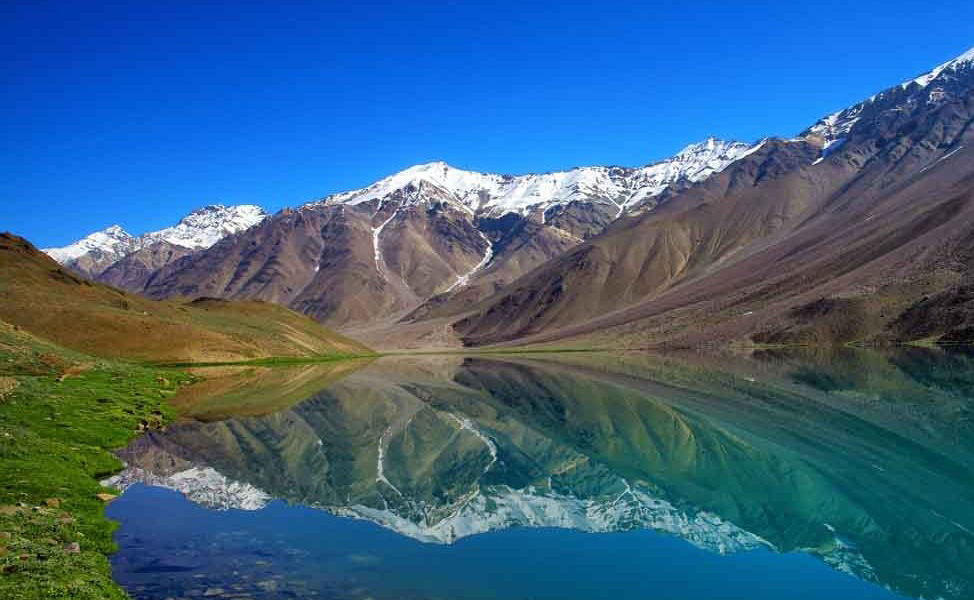
From Sachu we hiked up and over Baralacha La into the Chandratal Valley — said to be one of the best in Himachal Pradesh. The upper valley was captivating and we only saw one nomadic herder during our first day.
The lake at the south end of the trek where all the tourists go was a bit disappointing after all the hard work so we had a good laugh at that.
We had one more pass to cross before getting into the picturesque Spiti valley and this was our longest day at 38km. By now we were back to full strength.
Fascinating from a geological perspective, you can literally see how the Island of India crashed into the Asian Continent. Giant slabs of rock and seabed that were once 1000m below sea level now thrust up to 6000m above. (Image #9)
By walking you certainly have more time to see and appreciate this.
Spiti Valley is the great divide in the Himalaya with green fields and valleys once over Bhaba Pass to the south and the high Rupshu Plateau to the north, with salt lakes that feel like the roof of the world.
Back on our original trail and 4km from a village called Mud, a dog came out to greet us and followed us (not unusual). The next morning we had an early start at 5.20am and 50m down the road there was the dog curled up on the steps of another hotel. It started to follow us again. We blocked it at the first swingbridge and did everything to drive it away and stop it from following us but to no avail. It would follow us for the next three days and 50km over Bhaba pass at 4900m and we ended up sharing our meagre food supplies with it.
Bhaba trek and pass was definitely the most challenging of the journey so far, as we followed nomadic herders over the glaciated pass before camping with the nomads further down the valley. There was a section coming off the top of the pass that was very steep and pretty sketchy with loose grit and gravel over hard rock. At this stage I should explain that Jo doesn’t like heights and swing bridges and we are not serious trekkers, only doing a few basic overnight treks and day walks at home in New Zealand. This was at least two levels above Jo’s comfort levels so we agreed no more high passes and started a long journey to renew our Visas in Nepal (you only get 90 days at a time).
By the way when we reached the main road we stopped at a cafe and the owner knew a shepherd looking for a dog so hopefully she is still wandering around the mountains and finds her way home. While scary this was an amazing journey for us and the dog and it will remain a highlight.
After a week of travel and 2000km on buses to renew our visas, we restarted the trail and had only missed one high pass.
We spent several days hiking through the foothills in the rain before making a side trip to Gangotri which was always planned as an extra. Gangotri is a 22km walk up the valley (44k return) to the source of the Ganges. It was interesting on the bus up there to watch how excited the locals were to see the river as it is one of four sacred places Hindu want to visit in their lifetime. They were switching from one side of the bus to the other every time we crossed a bridge so they could still see the river. It was fascinating to see as they gathered water from the sacred river and cleansed themselves. It gave us a better understanding of its importance.
The scenery at the top of the valley was amazing. Image from Gangotri Valley folder … I’m thinking the DreamsTime one which I can download if we use it
The advanced forecast for our final push to Kedarnath wasn’t great so we had to increase the pace to beat the cloud and rain. We had three days to cover the last 80km with 2000m of altitude gain — mainly on the last day.
When we started this journey we were largely ignorant of the importance of this Temple but it is also one of the four must-visit locations for Hindu. There are 10,000 people that make the final 19km hike up to Kedarnath each day. Most travel by vehicle to the road end and then walk but many older or unfit people are unable to so they get carried in a wicker basket on porters’ backs, or on horseback. It was crazy. A real mash of horse shit and humanity heading towards one location as if it was a gold rush.
We didn’t particularly enjoy this last journey as we were pushed, bumped and jostled by people and horses. Having come from locations so remote we sometimes only saw one person in a day, this last leg was a shock.
But that is the journey to Kedarnath and part of the experience.
Our first impressions were that it looks a bit like a tent city because after a massive flash flood ten years ago much of the town is still being rebuilt. However the central square and temple were as we imagined and the mountains more monstrous than expected, towering over the temple.
We did a hike up to the glacier where we only saw two other people compared to the 10,000 in town. Finally in the evening we went for a last walk in town as the sun set and as we walked towards the temple, clouds blew up the valley from below and within seconds the mountains disappeared as if the final curtain had poetically come down on our journey.
Stats
We crossed 6 high passes and three mountain ranges, over a total of 803km. Total altitude gain was 42,150 feet, with 80% of it above 3500m and probably 50% above 4000m. Highest point 5260m with only 10.8% oxygen compared to 20.9% at sea level where we live.
We didn’t connect all the dots from Leh to Kedarnath but we did have two amazing months wandering through the greatest mountain range on earth.
The 2013 NORTH INDIA FLOODS — Considered India’s worst natural disaster since the 2004 tsunami, a midday cloudburst centered on the North Indian state of Uttarakhand saw 375% of the benchmark rainfall during a normal monsoon. This caused the melting of Chorabari Glacier at the height of 3800 meters causing devastating floods and landslides. Over 6000 people perished, while the destruction of bridges and roads left about 300,000 pilgrims and tourists trapped and in need of rescuing.